
Day One on the WABDR
Hey, just a heads up! This post contains Amazon affiliate links, and as an Amazon Associate I earn from qualifying purchases. Thank you!
This article is a continuation of an article series on my week-long motocamping trip on the Washington Backcountry Discovery Route (WABDR) in the Fall of 2022. If you haven’t seen the first article, start here!
The Night Before
In the late afternoon of Friday, Sep 2nd, my partner and I loaded up my bike on my Black Widow hitch carrier, stuffed my gear inside of the car, and drove up the East side of the Cascades towards the Canadian Border. Along the way, we were surprised to see apple orchards that continued for what felt like forever in all directions along the road!

Just as the sun started to set, we arrived at a quiet dispersed campground only 15 minutes South of the Canadian border. We quickly put together dinner and got some rest, which we would both need for the long day that lay in wait.
We woke to the sun peeking through the tent’s flaps, and we wasted no time in making breakfast and getting packed up! Below is a picture of the campsite just before we headed up to the border, where my partner would drop me off for my WABDR adventure.

The Route for Day One
Day one on the WABDR officially started at the Washington-Canada border, at a local border crossing Northwest of Oroville, WA. The route for the day traveled 73 miles South, and ended in the town of Conconully. I had two major landmarks to stop at. The first was a viewpoint from a place called Path Table, and the second was an old decrepit cabin and corral development called “Skull and Crossbones”.

The Canadian Border
When we arrived at the Canadian border, it was exceptionally quiet, and we were the only people around aside from the bored border patrol personnel. We noticed that some wildfire smoke had started to enter the valley, so I made a mental note to watch for more as I progressed through the adventure. We unloaded my bike and the gear from our car, and I posed for a quick picture (see below). With that, I started the WABDR!

Highlights of the Day
One of the first side trips of my route was the historical sign for the town of Nighthawk, and it was only twenty minutes from the start of the ride. While the sign was small, it painted a vast picture of the past – conjuring up images of bustling mines and homes full of resting miners in the late hours of the night. Knowing that I still had a lot of ground to cover, I took a quick picture of the sign and got back on my way.
My next stop, the Path Table viewpoint, was only 20 miles away. As I neared the viewpoint, I passed a tree that was decorated with random objects, Mardigras style. I picked a Starbucks gift card off of the tree, which ended up having a whopping $1.34 left on it! I know, I know, big spender. Other fun objects on the tree included scary voodoo dolls, shotgun shells, and a pair of scissors that looked perfectly functional.


I hopped back on the bike for a few more minutes before arriving at the Path Table viewpoint. I felt a bit robbed by the name of the waypoint, which I had discovered on the WABDR website. Unless I missed a turn, there was not much of a view to be had. All was well though, as it was still a great place to grab a snack and re-adjust some of my gear that had wobbled loose within the first leg of the ride.

I continued on my route, when around 15 miles later I noticed that my right leg felt a bit more warm than it usually did when riding uphill, and I smelled a scent similar to burning plastic, which is never a good sign on a bike. I pulled off to the side of the road to investigate.

As I discovered, I had managed to melt a gaping hole in the right side cover that protected my bags from my exhaust muffler. I was only half a day into my trip, and some of my more critical gear had already started to fail. Yikes! While brainstorming a fix, I realized that I had installed the Giant Loop Coyote bag (the big orange bag on the bike) closer to the front of the bike than in previous trips. This, paired with the heat coming off of the muffler, caused the side cover’s plastic to slowly deform until the plastic contacted the muffler and the cover started to melt.


While I now had to unfortunately replace the side covers, I knew I could easily solve the issue by moving the bag rearward, so that its weight would be better supported by the aluminum heat shield that Giant Loop provides with the install kit. I moved the pack backwards and hopped back on the trail!
My next destination, the Skull and Crossbones Cabin and Corral, was only a few miles away now. While on my way over, I ran into a few packs of cows. They seemed to be more interested in standing still than being polite and scooting to the side of the road, so we became acquainted while they were contemplating letting me through.

The cows and I parted ways and I arrived at the Skull and Crossbones waypoint! I figured that this would be a good opportunity to try out my new inexpensive and lightweight phone tripod. The tripod worked out great! My posing worked out… less great.


My last side trip for the day was Lone Frank pass, which was another eight miles away. This turned out to be an incredibly eventful eight miles.
Things that happened during those eight miles:
- I unwittingly entered a slow speed pursuit with a cow that was a little too interested in me, and
- I found an old outhouse with a rusty saw in some brush while slowly backing away from said cow.
- I admired the burnt forest from above and below with my lightweight DJI drone
- I flew my drone into a tree, rendering it dead weight for the rest of the trip.
- The cow caught up to me again, and I ran away
Here’s a quick visual story of Lone Frank pass (unfortunately missing the cows):


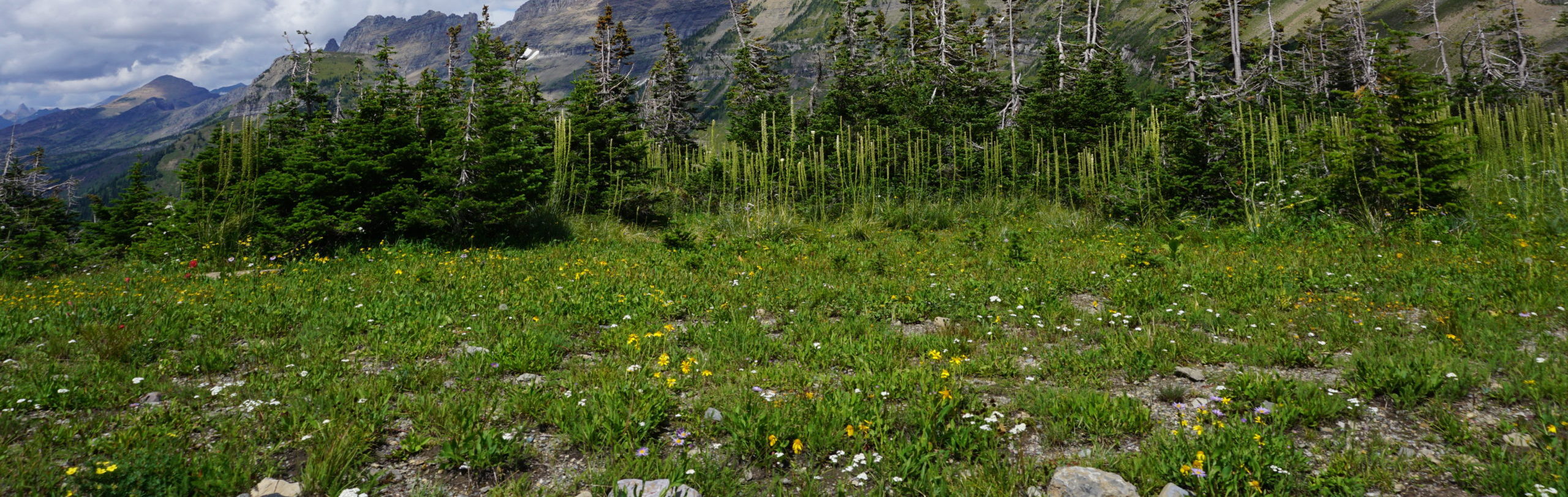
I collected myself from the wild time on Lone Frank Pass and headed to the final location of the day – Conconully! Along the way, I passed a 4×4 trail, Mutton Ridge, that looked like a blast. I would have to save that trail for another time. I also rode through a gorgeous open meadow just before dropping into Conconully – see the pics below!


Conconully
I reached Conconully just as the sun started to set, and I stepped inside the Sit’n Bull Saloon & Cafe for a burger and a beer. The burger was decent, and the beer was Coors banquet, so it was excellent as Coors always is. Even more interesting however, was my conversation with a local gentleman who told me about his past working at Boeing as a facilities engineer. He had worked for Boeing in Kent, WA for twenty-some years before moving out to Conconully with his wife to enjoy the mountains and solitude. One thing they didn’t expect was the yearly cycle of wildfires that Washington tends to get. The drought situation in the state has only been worsening year over year, and Mike and his wife have already had to evacuate their home due to wildfire danger twice since moving to Conconully. They expressed their appreciation for the wildland firefighters that put their lives on the line to save entire communities such as their own.
Mike also told me the story of how a seasonal Forest Service employee was treed by wolves only a few years ago while preparing for stream surveys at a campground North of where I was to stay. Hearing this story before heading into the hills to camp gave me great confidence in my safety while camping alone in the woods!
I paid my tab, parted ways with my new friends, and headed up to my campsite, just five miles outside of town. I was fortunate enough to catch enough light at camp to both set up my tent and explore a bit.

While exploring, I found some strange dirt tunnel systems in the burnt forest, which appeared to be the remnants of a burnt tree’s root system. The tree was nowhere to be found. One silver lining of wildfires is that they can bring strong crops of mushrooms, as evidenced by the one I found while hiking around my site.


I also managed to score some wild raspberries near my campsite, which was a nice surprise!

What an adventurous first day on the WABDR! Read about day two and three on the WABDR here!

If you have any questions or comments about the WABDR, please reach out through the contact form, or shoot me a message on Instagram – (@HighCaliberCamping).
-Colin