
Hey, just a heads up! This post contains Amazon affiliate links, and as an Amazon Associate we earn from qualifying purchases at no additional cost to you. Thank you!
Intro
If you’re anything like me, you understand the importance of reliable navigation, and have bounced between different navigation systems and devices trying to find the right system. Over the years, I’ve tried many different navigation and route planning tools, such as Google Maps, Google Earth, OnX, Gaia, Avenza, Rever, etc., but I always found them to be missing one thing or another. What I have discovered is that there is no “one-size-fits-all” solution, but there absolutely is a “one-size-fits-many”! I eventually realized that the mapping tools I use for human-power adventures could also provide an excellent solution for motorized backcountry travel.
My Navigation Tools
I use a combination of devices for my outdoor adventures – hiking, biking, skiing, overlanding, motocamping, etc. This system is the culmination of many years of trial and error while trying to work inefficiencies out of the system. While some inefficiencies still exist, I am always looking to improve my navigation system, and will keep this page updated to reflect any changes.
Navigation Device: iPhone SE (any modern smartphone is fine)
- Why the iPhone SE you ask? Well, I already carry my phone on my travels, and space and weight are usually at a premium during adventures. Combining functionality without compromising performance is a no-brainer. Most modern smartphones are relatively waterproof and with the addition of an Otterbox Defender case, the device is protected from fall damage and most dust intrusion. I use a gamut of phone apps to navigate while out on adventures. For on-foot adventures, I rely heavily on Trailforks (subscription-based), Mtb/Mtn/Hiking Project, and CalTopo (subscription options), and for motorized adventures I primarily lean on Google Maps and CalTopo.
Backup Navigation Device: Garmin InReach Explorer+ and Garmin Instinct GPS Watch
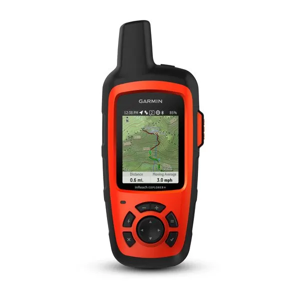

- The Inreach Explorer+ is an extremely rugged GPS navigator, satellite communicator, and SOS device. It has all of the best features of a GPS in a small package, and it can take any abuse thrown at it. Before I head out on adventures in remote areas, I load my route onto the device (as a .gpx file) and double check that my Garmin subscription is still active. Garmin also offers a variety of spine-clip style mounts for these GPS devices for mounting to backpacks and vehicles as well.
- The Instinct GPS watch is my last-ditch bail method in case my primary (phone) and backup (Garmin Inreach Explorer+) modes of overlanding navigation get put out of their misery. The watch can at least get me along my route with turn notifications on a GPX track. It won’t be fun, but I’ll survive.
Navigation Software: Google Maps and CalTopo

- Google Maps works perfectly when getting around and between most towns. May as well take advantage of its simplicity!
- CalTopo is the best backcountry mapping tool for my navigation needs because of the extensive layer (I mostly use Forest Service and BLM layers) and layover functionality it offers. It is also robust enough to replace a GPS, as long as the necessary offline layers are downloaded on the navigation device before heading out. The mobile user interface is excellent and easy to navigate, even while wearing thick gloves. I rode the entire WABDR on my motorcycle with CalTopo on my phone as my primary navigation
Navigation Device Charging:
- Hiking: I typically focus on preserving battery power, and on longer trips I bring a small auxiliary battery pack as a backup. For multi-week expeditions, I would consider bringing a small solar panel if necessary. REI has a great article on this sort of thing!
- Car: A simple USB charger cable from a 12V socket charger to my phone.
- Motorcycle: On my 1991 Honda XR600R I run an aftermarket 5V USB charger kit that I installed. The charger pulls power from a small 12V battery located in my bike’s airbox, which receives constant power from the (upgraded) stator while running.
Navigation Device Mount:
- Hiking: My phone goes in my pocket, and I use the carabiner that comes with the Garmin InReach to clip it onto my backpack’s shoulder straps.
- Car: I use this phone holder to keep my phone visible while navigating cities and networks of backroads.
- Motorcycle: The “Perfect Squeeze” phone mount, which is made by an independent small-run shop called Hondo Garage. It’s bulletproof, easy to use, and you won’t lose your phone offroad. Just make sure to also get the “Buzz-Kill” vibration damper, which is package in the base product link above (Mine was fine without the damper for a bit, but I went on a fast and chunky double-track a few hours into my first ride, and when I used my camera app I could tell that it had temporarily damaged my phone’s auto focus and optical image stabilizer). Apple even released a statement saying that this such damage is highly likely, and damage is cumulative, so it is better to just get a damped mount from the start.


Physical Maps:
- Of course, you should always carry a map with you. I print my route out and bring it along in case all other methods fail. Be sure to bring a compass, since a map is fairly useless without a compass and knowledge of how to use the two together.
Parting Thoughts
All of the above information is about the navigation toolset that I have come to know and trust throughout my travels. The navigation tools that you use may serve your specific needs much better than what I use, and that’s okay! If you have any questions about the tools listed on this page please reach out through our contact form, or on Instagram – (@HighCaliberCamping).