Days Four and Five Motocamping the WABDR
This article is the fourth in a five article series telling the story of my week-long motocamping trip on the Washington Backcountry Discovery Route (WABDR) in the Fall of 2022. If you haven’t already seen the first article, start here!
The Route for Day Four on the WABDR
My plan for day four on the WABDR consisted of 115 miles of riding, and the trail had turned to a sandy/rocky desert. My starting point was the last-minute campsite I had picked the previous day, South of Wenatchee, and the day’s route took me to Bethel Ridge, just North of Rimrock Lake.

Highlights of Day Four on the WABDR
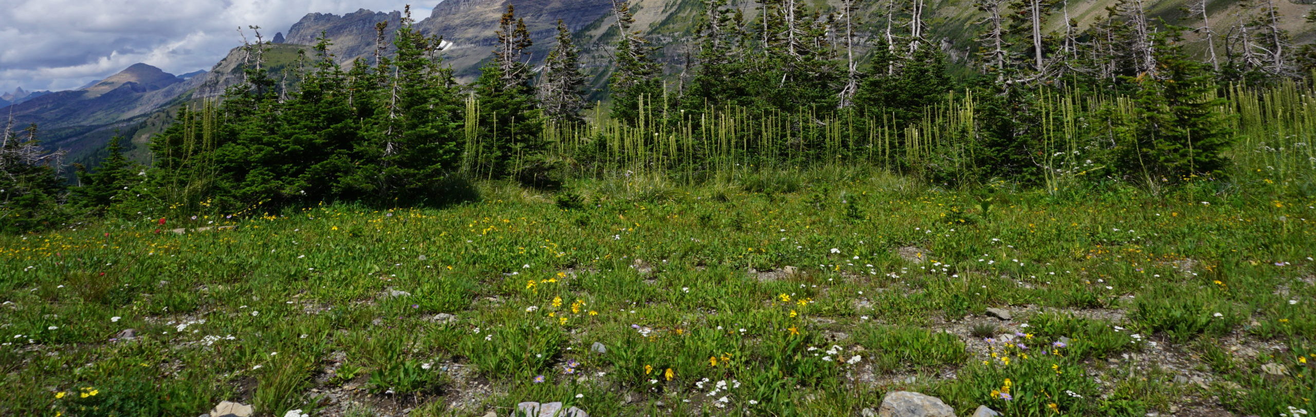
I started my day by waking up in a beautiful subalpine meadow at the Ken Wilcox Horse Camp. There was only one other group in the campground, and they were getting ready to leave right about when I woke up. Breakfast. Brush teeth. Check the bike. Pack up. Check the day’s route. Kickstart. Go.


I briefly stopped at a destination called Lion Rock, which gave excellent, though smoky, views of the Enchantments and Mt. Rainier.


Soon I was descending into the town of Ellensburg, in search of lunch and food, water, and gas resupply.

I picked up a few freeze-dried meals in Ellensburg and threw back a decent burger at one of the local taverns adjacent to the town’s outdoor gear center. It was time to head to the next town, Nile. In between Ellensburg and Nile is a section of the WABDR called “Baby Head Hill”, which is a segment of desert road chock-full of baby-head sized rocks. There’s no grip and it is hard to stay upright in this section. Fortunately I was riding the WABDR “backwards” from the traditional route, so I was able to descend this section, which was considerably easier than climbing the loose rock. However, the section between Ellensburg and Nile was my least favorite part of the entire trail because it was incredibly hot, remote (not in a fun way), and the road surface was full of sharp fist-sized rocks, just itching to give you a flat tire.


This segment of the ride was physically demanding and emotionally punishing. Hot sun and fist-sized rocks for miles on end. I usually enjoy desert riding, but the road surface made it particularly rough to do so. To top things off, I was alone and objectively very far from help if anything went wrong with me or the bike. For these reasons, I chose to ride conservatively for most of this section.
In Nile I filled up on gas and stopped for a quick break at a highway underpass to collect myself for the road up to the campsite. I don’t have any pictures from the section between Nile and my campsite at Bethel Ridge because I was focused on keeping my bike right side up and setting up camp before dark.


Eighty miles after leaving Ellensburg I arrived at my campsite, and as I did so I flushed out an entire family of mountain turkeys!

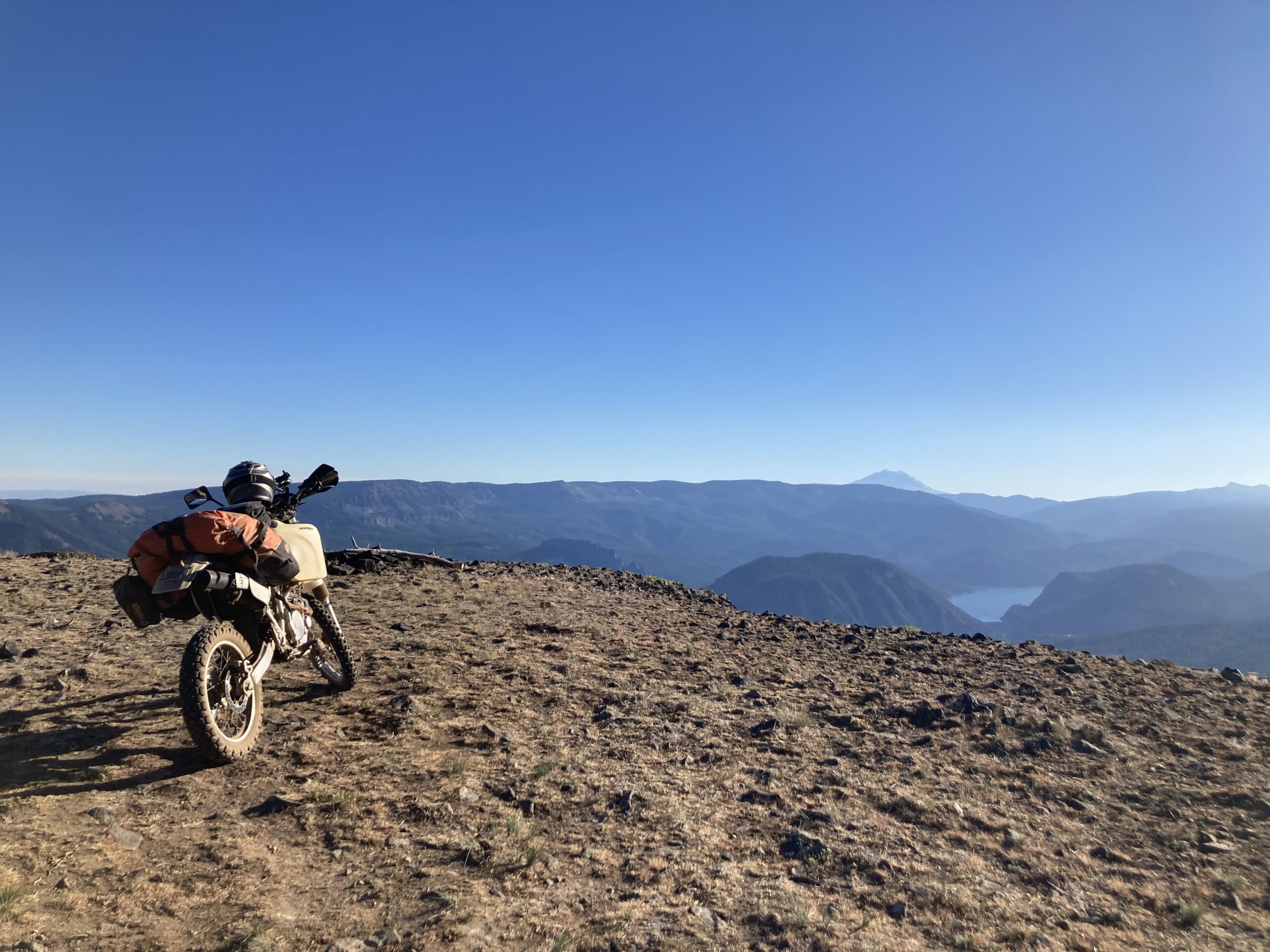
As for my campsite on Bethel Ridge? It was nothing short of stunning. Washington put on its best summer face (read: no clouds) to give me the sunset of a lifetime. I’ll be back.
Here’s a short photo epic of one of my favorite campsites of all time:


The Route for Day Five on the WABDR
My fifth day on the WABDR didn’t involve much riding. My overall plan was to climb a nearby mountain named Shellrock Peak. Afterwards I’d trip down to Shellrock Lake to find some food. Between hiking and riding I put in just under 50 miles.

Highlights of Day Five on the WABDR
On day five on the WABDR I awoke to partially cloudy skies and a brisk breeze on top of Bethel Ridge. I packed in a freeze-dried meal and was off to the day’s adventure.


I started down the Forest Service road connecting to the Shellrock Peak trail. Mt. Rainier soon reared its lovely head to say hi! Luckily, I’d continue to find excellent views of Rainier for the entire day.

After six miles of riding I reached the boundaries of the Wilderness area, which meant it was time to dismount my bike and put on my hiking shoes.


When I came to the junction for Shellrock peak I split off of the main trail and bushwhacked for a few hundred feet in the general direction of the ridge I was looking to climb.

After a bit of wandering and a few wrong turns I found myself climbing the talus of Shellrock Peak!

The feature that initially drew me to climbing Shellrock Peak was the columnar rocks that sharpened its ridge. I had seen pictures online of distinct geological formations that I wanted to see firsthand. I discovered that these rocks form the entire ridge of the peak. It was a treat to slowly make my way past column after column as I journeyed towards the summit.


When I reached the top of Shellrock Peak I signed the summit register and had lunch. The top of the mountain was composed of crashing waves of talus. I’ve never seen anything quite like it before, so I was a bit bummed when it came time to head back to my bike.

Four miles of hiking later I found myself back on my motorcycle. I rode down to Rimrock Lake to try to find dinner, but the town was closing down for the coming winter, so nobody was serving food. I picked up a delicious huckleberry cider and a chocolate bar from a convenience store claiming to be a “grocery store”. If you’re able to thrive long-term while consuming only beer, candy, and instant rice I’d love to know both your secrets and your blood pressure.
Back at camp I was treated to another incredible fiery sunset on Bethel Ridge.


That’s the end of day five on the WABDR! Only two more days to go until the end of this wonderful trip. Finish reading in “Completing the WABDR“!
If you have any questions or comments about the WABDR, please reach out through the contact form, or shoot me a message on Instagram – (@HighCaliberCamping).
-Colin